The Big Push Happening in Seattle and San Francisco
- The median commute distance for higher-income Downtown Seattle workers has been roughly constant for more than a decade. At the same time, the median commute distance for lower-income Downtown Seattle workers has increased sharply in recent years.
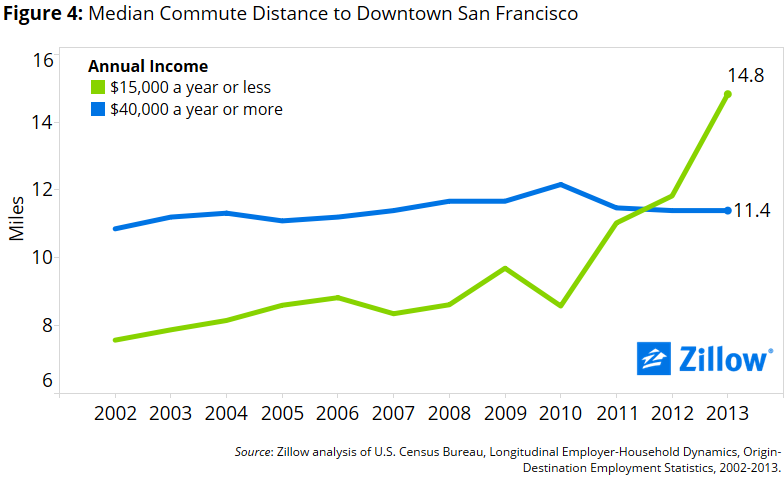
- A similar, if much more recent, trend is observable in Downtown San Francisco. In contrast to a decade ago, lower-income workers in Downtown San Francisco have longer commutes than higher-income workers in Downtown San Francisco.
- The trend indicates a rapid deterioration in housing affordability for low-income workers in areas reasonably close to both cities’ downtowns over the past decade.
Similar to many large American cities, Seattle’s downtown core (home to Zillow HQ since 2006) has experienced a resurgence over the past decade. New buildings have broken ground, public transit has expanded (including the inauguration of a new light rail) and employment has boomed. But in the midst of the boom, perhaps unsurprisingly, not everyone working in Downtown Seattle has fared similarly.
Increasingly, lower-income workers are finding themselves searching for affordable housing farther and farther afield from the downtown jobs center.
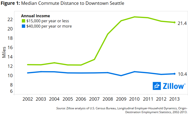
Since 2009, the median commute distance of low-income employees working in downtown Seattle has flattened and even fallen somewhat, perhaps a testament to the city’s efforts to expand its affordable housing supply. But the median commute distance for the lowest earners remains stubbornly high, and well above both pre-recession levels and the typical commute distance faced by wealthier peers.
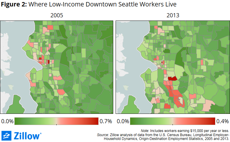
The core living areas for lower-income downtown Seattle workers has shifted gradually south over time (figure 2). In 2005, 5.9 percent of lower-income downtown Seattle workers lived in the downtown-adjacent neighborhoods of Capitol Hill, First Hill, South Lake Union, Belltown, Lower Queen Anne and Pioneer Square. By 2013, the share of lower-income workers living in these near-downtown neighborhoods had halved, to 2.6 percent. Although it has long been a popular residence area for lower-income Downtown Seattle workers, Rainier Valley – stretching south from the city’s industrial district just south of downtown toward Seattle-Tacoma International Airport – is increasingly home to many of the downtown core’s lower-paid workers.
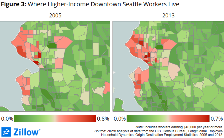
The footprint of higher-income downtown Seattle workers hasn’t changed as dramatically over the past decade. But there is very clearly a larger presence of higher-paid downtown Seattle workers in the Capitol Hill, South Lake Union, Lower Queen Anne, Wallingford, Ballard, Fremont and West Seattle neighborhoods (figure 3).
While the distances between the homes and workplaces of higher-income Seattleites and San Franciscans who work in the cities’ downtown cores have been flat over the past decade, in both cities lower-income workers are facing longer commutes.
The precise reasons behind these shifts are unclear, although common culprits include deteriorating housing affordability in the neighborhoods adjacent to downtown and the evolving employment base in the two city centers. Other explanations are more benign. For example, expanding public transit options could make it easier for lower-income workers to live farther afield. While the exact causes remain debatable, something is very clearly changing.
Methodology
To calculate the median commute distance Downtown Seattle workers, we used data from the Census Bureau’s Longitudinal Employer-Household Dynamics Origin-Destination Employment Statistics (LEHD/LODES), allowing us to study where people work and live at very small geographic levels.
For each year, we computed the distribution of people who work in Downtown Seattle by the census tracts where they reside. For those more familiar with the geography of Seattle, we define “downtown” as the area roughly bounded by Pioneer Square on the south, Interstate 5 on the east, Denny Way on the North and Elliot Bay on the west. For Downtown San Francisco, we included roughly the area bounded by Market Street on the south, Broadway on the north, Grant Avenue on the west and Davis Street on the east.
We then computed the Euclidian distance (the straight-line distance between the centers of the two census tracts) between each residence census tract and the downtown of the respective cities, and took the weighted median for workers in each of the two income groups reported here. Although not exact, Euclidian distance is generally viewed as a very good approximation for the more complex network distance, which accounts for the road network.