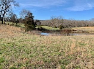
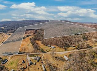
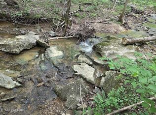
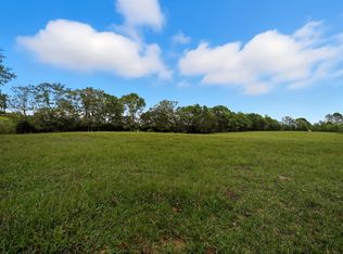
The +/- 54 Acre Big Bottom Farm is well-known in White and Van Buren Counties for its location on and fronting the scenic headwaters of the Caney Fork River. The shoals lying just upriver from the confluence with Cane Creek are reported to be the high-water mark for the downstream flood control reservoir. Cane Creek is a primary creek feeding north and off the Cumberland Plateau to the valley from the 30,000 acre Fall Creek Falls Tennessee State Park located about 20-miles to the south near Spencer. Big Bottom was referred to by local farmers and timbermen as the area east of the river ford which is comprised of modest sized open fertile fields, large limestone boulders, and flood plain at this valley forming water off the plateau to the east and south. The oldest of the Tennessee Valley Authority hydroelectric and water control dams (constructed 1915) is downstream about seventeen miles west and is known as Great Falls Dam, Rock Island, Tennessee. The free-flowing Caney Fork River forms east of the Big Bottom farm shoals from several creeks to the west, including Bee Creek, which drain and originate on and off the plateau. Many of these creeks form in the State of Tennessee’s 10,000-acre Bridgestone/Firestone Centennial Wilderness area. This remote yet accessible property makes the Big Bottom Farm unique. The most famous sites in the state’s wilderness area are Scotts Gulf and Lost Creek, which are heavily forested with native hardwoods. This immediate area is one of the most beautiful, pristine, yet assessable wild places left in Tennessee. Because of its lack of human development activity, it is attractive to a variety of wildlife, spelunkers, hunters, and hikers. This area is a vast unspoiled wilderness owned by the state and covers an area between Cumberland, White and Van Buren Counties in Tennessee. There is a pavilion constructed down by the river's edge. No soil work completed on the site but the higher elevation would make an incredible homesite location.
Active
$1,699,000
0 Big Bottom Rd, Sparta, TN 38583
--beds
--baths
54Acres
Farm
Built in ----
54 Acres Lot
$-- Zestimate®
$--/sqft
$-- HOA
What's special
- 384 days |
- 122 |
- 3 |
Zillow last checked: 8 hours ago
Listing updated: August 04, 2025 at 01:21pm
Listing Provided by:
James Spencer, CRB Broker/Owner 615-804-2571,
Mossy Oak Properties, Tennessee Land & Farm, LLC 615-879-8282
Source: RealTracs MLS as distributed by MLS GRID,MLS#: 2762488
Facts & features
Interior
Interior area
- Total structure area: 0
Property
Features
- Levels: Three Or More
- Has view: Yes
- View description: Valley, River
- Has water view: Yes
- Water view: River
- Waterfront features: River Front
Lot
- Size: 54 Acres
- Features: Level, Rolling Slope
- Topography: Level,Rolling Slope
Details
- Parcel number: 099 02903 000
- Zoning: Agri
- Special conditions: Standard
Community & HOA
HOA
- Has HOA: No
Location
- Region: Sparta
Financial & listing details
- Annual tax amount: $851
- Date on market: 11/22/2024
- Inclusions: Land And Buildings
- Road surface type: Asphalt
Estimated market value
Not available
Estimated sales range
Not available
Not available
Price history
Price history
| Date | Event | Price |
|---|---|---|
| 8/4/2025 | Price change | $1,699,000-8.1% |
Source: | ||
| 3/25/2025 | Price change | $1,849,000-7.5% |
Source: | ||
| 11/22/2024 | Listed for sale | $1,999,000 |
Source: | ||
Public tax history
Public tax history
Tax history is unavailable.BuyAbility℠ payment
Estimated monthly payment
Boost your down payment with 6% savings match
Earn up to a 6% match & get a competitive APY with a *. Zillow has partnered with to help get you home faster.
Learn more*Terms apply. Match provided by Foyer. Account offered by Pacific West Bank, Member FDIC.Climate risks
Neighborhood: 38583
Nearby schools
GreatSchools rating
- 6/10Woodland Park Elementary SchoolGrades: PK-5Distance: 6.9 mi
- 6/10White Co Middle SchoolGrades: 6-8Distance: 8.9 mi
- 7/10White County High SchoolGrades: 9-12Distance: 9 mi
Schools provided by the listing agent
- Elementary: Woodland Park Elementary
- Middle: White Co Middle School
- High: White County High School
Source: RealTracs MLS as distributed by MLS GRID. This data may not be complete. We recommend contacting the local school district to confirm school assignments for this home.


- Loading
