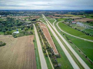
Here is an excellent opportunity to own 4.61 +/- acres of potential future development in western Dane County. Located under one mile from the Village of Mount Horeb, this property sits in an excellent location between US Highway 151 and Highway ID. Overall, the property is located within the Town of Blue Mounds and also within the extraterritorial jurisdiction of the Village of Mount Horeb. The Village of Mount Horeb has classified the property as ?Planned Mixed Use? according to the Future Land Use section of their Comprehensive Plan. The property is currently zoned A1EX, which is an agricultural zoning. Buyers should be aware the property will need to be rezoned and have the appropriate approvals for uses other than agriculture.
Closed
$80,000
4.61 County Road ID, Mount Horeb, WI 53572
--beds
--baths
4.61Acres
Unimproved Land
Built in ----
4.61 Acres Lot
$-- Zestimate®
$--/sqft
$-- Estimated rent
Home value
Not available
Estimated sales range
Not available
Not available
Zestimate® history
Loading...
Owner options
List your home for rent
Find your next renter with Zillow Rental Manager. Plus, with online applications, you can quickly screen prospective tenants – for free.
Learn moreRefinance and save
$437/mo
Est. payment
Refinancing to a lower rate could help reduce your monthly payments and save thousands over the life of the loan.
See today's rates$437/mo
Est. payment
Explore your selling options
Work with a Zillow partner agent
Leverage their expertise and Zillow's premium Showcase listings to get your home seen by more buyers.
Get startedList with your own agent
Get your home in front of millions of buyers by listing it on Zillow.
Learn how to do itSell it yourself
Take full control of how buyers see your home on Zillow by listing For Sale by Owner (FSBO).
List your homeWhat's special
Zillow last checked: 7 hours ago
Listing updated: April 26, 2024 at 08:08pm
Listed by:
Jason Heller 815-858-4403,
Midwest Land Group LLC
Bought with:
Jack Mlsna
Source: WIREX MLS,MLS#: 1968631 Originating MLS: South Central Wisconsin MLS
Facts & features
Property
Lot
- Size: 4.61 Acres
- Features: Level, Sloped
Details
- Parcel number: 060610497113
- Zoning: A1EX
- Special conditions: Arms Length
Utilities & green energy
- Sewer: No Waste Disposal System
- Water: Well Required
- Utilities for property: Natural Gas Connected, Electricity Connected
Community & neighborhood
Location
- Region: Mount Horeb
- Municipality: Blue Mounds
Other
Other facts
- Listing terms: Sell in Entirety
Price history
| Date | Event | Price |
|---|---|---|
| 4/25/2024 | Sold | $80,000-36% |
Source: | ||
| 3/14/2024 | Pending sale | $125,000 |
Source: | ||
| 12/19/2023 | Listed for sale | $125,000 |
Source: | ||
Public tax history
Tax history is unavailable.
Neighborhood: 53572
Nearby schools
GreatSchools rating
- NAMount Horeb Primary CenterGrades: 1-2Distance: 1.4 mi
- 7/10Mount Horeb Middle SchoolGrades: 6-8Distance: 1.9 mi
- 8/10Mount Horeb High SchoolGrades: 9-12Distance: 1.8 mi
Schools provided by the listing agent
- Elementary: Mount Horeb
- Middle: Mount Horeb
- High: Mount Horeb
- District: Mount Horeb
Source: WIREX MLS. This data may not be complete. We recommend contacting the local school district to confirm school assignments for this home.
- Wisconsin
- Dane County
- Blue Mounds
- 53572
- 4.61 County Road ID