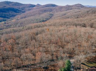
Land is located in Bedford County just across the Botetourt County line on Bore Auger Rd (for GPS the closest real address is across the road at 5351 Bore Auger Rd, Blue Ridge VA). Tax map # is 102 A 12. There is no for sale sign on the property. I inherited the land from my parents who bought it in 1963. We primarily use the land for recreation like hunting and hiking. There is about 1,200 feet of state road frontage with multiple building sites along the road and all throughout the property. The land is all wooded mountain top and consist of valleys, hills and an overgrown flat area..see the topo map in the pictures. There are some views but they're hard to see due to the trees. There's a residential power line easement that runs through the property. There's also a small stream in the back of there property. The land is currently on Land Use Tax for Timber harvesting. The last timber harvest was a select cut about 25 years ago. If you have any questions or would like to take a look, please email or call and leave a message. Please no real estate agents unless you have a client interested in the property. I have a real estate agent contracted for other marketing options. Thanks, Mark
This property is off market, which means it's not currently listed for sale or rent on Zillow. This may be different from what's available on other websites or public sources.