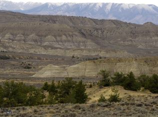
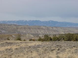
159.22 remote acres on a county road near the Pryor Mountains with great views. If you are looking for privacy, a hunting camp or just your own place far from the rat race of the big city, this may be the place. No known covenants, this land is priced to sell. It offers some great views of the Pryor Mountains, as well as views of the Beartooth Mountains, Absarokas and Bighorns. Cottonwood County road is a gravel road that gives you good access, just 2.7 miles off the state highway. The land is a blank slate, waiting for someone's dreams. Mostly grass and sagebrush, but it has some great elevated build sites. The land is just east by a mile or two from 80,000 acres of BLM and State public land. Very dry area, so winter access is not usually a problem, but may require some snow plowing on occasion. Your nearest neighbor is 1.5 miles away to the east where the electric is located. Lots of sun for solar power. Owner will consider financing with at least 20% down. Located 25 miles south of Bridger, MT (pop 750), 65 miles southwest of Billings, MT (pop 120,000) and 32 miles north of Powell, WY (pop 6500). The town of Frannie, Wyoming (pop 150) is 10 miles to the south.
Sold
Price Unknown
Cottonwood Rd, Bridger, MT 59014
--beds
--baths
159.22Acres
Unimproved Land
Built in ----
159.22 Acres Lot
$-- Zestimate®
$--/sqft
$-- Estimated rent
Home value
Not available
Estimated sales range
Not available
Not available
Zestimate® history
Loading...
Owner options
List your home for rent
Find your next renter with Zillow Rental Manager. Plus, with online applications, you can quickly screen prospective tenants – for free.
Learn moreRefinance and save
Refinancing to a lower rate could help reduce your monthly payments and save thousands over the life of the loan.
See today's ratesExplore your selling options
Work with a Zillow partner agent
Leverage their expertise and Zillow's premium Showcase listings to get your home seen by more buyers.
Get startedList with your own agent
Get your home in front of millions of buyers by listing it on Zillow.
Learn how to do itSell it yourself
Take full control of how buyers see your home on Zillow by listing For Sale by Owner (FSBO).
List your homeWhat's special
Zillow last checked: 7 hours ago
Listing updated: June 09, 2025 at 03:29pm
Listed by:
Dean Petty 406-580-3372,
Mountainlands of MT Realty
Bought with:
Non Member
Non-Member Office
Source: Big Sky Country MLS,MLS#: 392925Originating MLS: Big Sky Country MLS
Facts & features
Interior
Interior area
- Finished area above ground: 0
Property
Features
- Has view: Yes
- View description: Mountain(s), Rural, Southern Exposure
- Waterfront features: None
Lot
- Size: 159.22 Acres
- Features: Level, Rolling Slope
- Topography: Level,Rolling,Sloping
Details
- Additional parcels included: Geocode 10019113102010000
- Parcel number: 0001519700
- Zoning description: NONE - None/Unknown
- Special conditions: Standard
Utilities & green energy
- Utilities for property: Electricity Not Available, None
Community & neighborhood
Location
- Region: Bridger
- Subdivision: None
Other
Other facts
- Listing terms: Cash,Contract,3rd Party Financing
- Road surface type: Gravel
Price history
| Date | Event | Price |
|---|---|---|
| 6/9/2025 | Sold | -- |
Source: Big Sky Country MLS #392925 Report a problem | ||
| 6/4/2025 | Pending sale | $169,900 |
Source: Big Sky Country MLS #392925 Report a problem | ||
| 5/10/2025 | Contingent | $169,900 |
Source: Big Sky Country MLS #392925 Report a problem | ||
| 11/6/2024 | Listed for sale | $169,900-83% |
Source: Big Sky Country MLS #392925 Report a problem | ||
| 10/4/2024 | Contingent | $999,900 |
Source: | ||
Public tax history
Tax history is unavailable.
Neighborhood: 59014
Nearby schools
GreatSchools rating
- 3/10Bridger Elementary SchoolGrades: PK-6Distance: 19 mi
- 7/10Bridger 7-8Grades: 7-8Distance: 19 mi
- 5/10Bridger High SchoolGrades: 9-12Distance: 19.1 mi
- Montana
- Carbon County
- Bridger
- 59014
- Cottonwood Rd