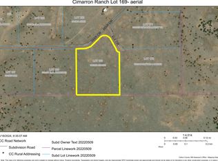
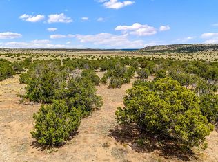
Video of property: https://youtu.be/x0GAr6pf9Fw Spacious 14.59 acre Catron County property with a great view overlooking mountains. Great site for enjoying nature or building a rural home. 32 min drive to the town of Quemado, with local businesses. Cozy and secluded but also driving distance to essential resources in Quemado or Spingerville. We're offering this at a very low price which makes it great for direct use or investment. We specialize in finding deals on property and passing savings on to customers. Notice that this is a fraction of the price of most properties of this size in this area. Access: Convenient access using dirt road off of US-60. You can type these GPS coordinates in to google maps exactly to look it up: 34.273466,-108.865040 Nearby Businesses: Largo Cafe and Motel, Quemado (32 min) Kim's Corner Hair Salon, Quemado (32 min) White Mountain Region Medical Center, Springerville (34 min) Scenic Natural features: Cimarron Mesa (2 miles) Black Peak (7 miles) Escudilla Mountain (10 miles) Nearby Towns: Quemado, NM (32 minutes) Springerville, AZ (34 minutes) Nearby Cities: Socorro (2h) Albuquerque (3h) Other points of interest: Casa Malpais Archaeological Park and Museum (33 minutes) About the nearby town Quemado, NM: Quemado is a census-designated place in Catron County, New Mexico, United States. As of the 2010 census it had a population of 228.Walter De Maria's 1977 art installation, The Lightning Field, is between Quemado and Pie Town, New Mexico. Jerry D. Thompson, historian of the American Southwest, was reared in Quemado. About the nearby town Springerville, AZ: Springerville is a town in Apache County, Arizona, United States, within the White Mountains. Its postal ZIP Code is 85938. As of the 2010 census, the population of the town was 1,961. Springerville sits at an elevation of 6,974 feet (2,126 m) above sea level. Along with its neighbor Eagar, the communities make up the place known as Round Valley which is in the central-eastern part of Arizona close to the New Mexico border. Property Information: Size: 14.59 Acres County: Catron State: NM APN: 2114001105495 GPS: 34.273466,-108.865040 Legal Description: LOT:178 CIMARRON RANCH 2 LOT 178 CONT. Zoning: Residential Yearly Tax: Approximately $117 GPS location: Center: 34.273466,-108.865040 NW: 34.274191,-108.866370 SW: 34.272158,-108.866360 (Deer Cir) SE: 34.272466,-108.863751 (Deer Cir and Arabian Way) NE: 34.274140,-108.860881 (Arabian Way) Payment: We accept various forms of payment and can discuss options. Some options include: 1. Cashier's check by Priority Mail with tracking 2. Wire Transfer 3. Zelle 4. Others (discuss with us) Contact: Rick rgiuly@gmail.com LandPixie.com 858-531-0069
This property is off market, which means it's not currently listed for sale or rent on Zillow. This may be different from what's available on other websites or public sources.