TERRENO EN ISABELA, PUERTO RICO - VENTA EXCLUSIVA
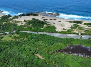
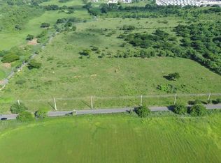
Ubicación: Sector Bajura, Isabela, Puerto Rico
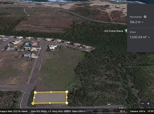
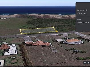
Área total: 28,604.26 m² (aprox. 6.68 cuerdas)
Número de catastro: 003-000-007-90
Coordenadas: Lat. 18.51927816, Lon. -67.04392540
¿Estas buscando una oportunidad úni en una zona con un potencial ecológico, turístico o de conservación? Este terreno esta ubicado dentro del Área de Planificación Especial de la Zona Carsica (APE-ZC), y esta clasificado como SREP-E (Suelo Rústico Especialmente Protegido - Ecológico), ideal para proyectos sustentables conforme a las leyes ambientales de Puerto Rico.
Zonificación y Usos Permitidos
Clasificación PUT: SREP-E (83%), VIAL (11%), SREP (5%)
Uso recomendado:
Proyectos de turismo ecológico, senderismo, observación de aves
Conservación ambiental, estudios e investigación
Agricultura sustentable o siembras controladas según reglamentación
Infraestructura liviana no permanente sujeta a permisos especiales
(No se permite construcción residencial o comercial tradicional por tratarse de una zona protegida y costera)
Características Ambientales
Zona de Inundabilidad: VE (46.8%) / AE (53.2%)
Clasificación de Suelo (NRCS): Ch (94.1%), Td (5.1%)
No se encuentra en floodway activo
Reglamento aplicable: Plan de Uso de Terrenos, Reglamento Conjunto
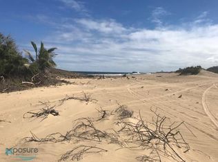
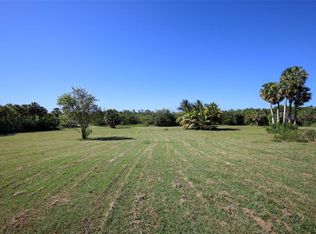
Este terreno cuenta con acceso vehicular directo desde la carretera estatal y esta a pasos de una de las playas mas vírgenes de Isabela, rodeado de vegetación natural, dunas y ecosistemas costeros.
Importante: Este terreno se vende con plena divulgación de sus clasificaciones y restricciones de uso, conforme a las regulaciones de la Oficina de Gerencia de Permisos (OGPe), Junta de Planificación y Departamento de Recursos Naturales y Ambientales (DRNA). Se requiere gestión de permisos para cualquier intervención conforme a las leyes vigentes.
---------------------------------------------------------------
LAND FOR SALE IN ISABELA, PUERTO RICO - EXCLUSIVE LISTING
Location: Sector Bajura, Isabela, Puerto Rico
Total Area: 28,604.26 m² (approx. 6.68 cuerdas)
Property ID (Catastro): 003-000-007-90
Coordinates: Lat. 18.51927816, Lon. -67.04392540
This is a unique opportunity to acquire land located in a highly protected natural setting within the Special Planning Area of the Karst Region (APE-ZC). Classified as SREP-E (Specially Protected Rustic Land - Ecological), this property is ideal for environmentally sustainable uses, in full compliance with Puerto Rico’s environmental laws and land-use regulations.
Zoning & Permitted Uses
Land Use Classification (PUT): SREP-E (83%), VIAL (11%), SREP (5%)
Recommended Uses:
Ecotourism projects, hiking trails, birdwatching
Environmental conservation, research, and education
Sustainable agriculture or managed planting (subject to regulation)
Light, non-permanent structures with proper environmental permits
(Residential or commercial construction is not permitted due to the property's protected classification)
Environmental Features
Flood Zone: VE (46.8%) / AE (53.2%)
Soil Classification (NRCS): Ch (94.1%), Td (5.1%)
Not located in a designated floodway
Applicable regulations: Land Use Plan (Spanish), Joint Permits Regulation (Spanish)
The property has direct access from the main road and is surrounded by protected natural landscapes, including dunes, native vegetation, and ecological corridors.
Important: This land is offered with full disclosure of its zoning and environmental classifications. Any future use or development must comply with current permitting regulations as established by OGPe, the Puerto Rico Planning Board, and the Department of Natural and Environmental Resources (DRNA).
Lot/land
$1,575,000
State Route 466 Km #11.7, Isabela, PR 00662
0beds
0baths
7.07Acres
Unimproved Land
Built in ----
7.07 Acres Lot
$-- Zestimate®
$--/sqft
$-- HOA
What's special
- 167 days |
- 20 |
- 3 |
Zillow last checked: 8 hours ago
Listing updated: October 02, 2025 at 01:27am
Listed by:
Irithell Gonzalez 787-549-2938,
KW Puerto Rico
Source: Amplia,MLS#: PRKW878A00Originating MLS: PR
Estimated market value
Not available
Estimated sales range
Not available
Not available
Price history
Price history
| Date | Event | Price |
|---|---|---|
| 10/22/2025 | Listed for sale | $1,575,000 |
Source: Amplia #PRKW878A00 Report a problem | ||
Public tax history
Public tax history
Tax history is unavailable.BuyAbility℠ payment
Estimated monthly payment
Boost your down payment with 6% savings match
Earn up to a 6% match & get a competitive APY with a *. Zillow has partnered with to help get you home faster.
Learn more*Terms apply. Match provided by Foyer. Account offered by Pacific West Bank, Member FDIC.Climate risks
Neighborhood: 00662
Nearby schools
GreatSchools rating
No schools nearby
We couldn't find any schools near this home.


- Loading
