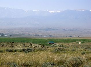
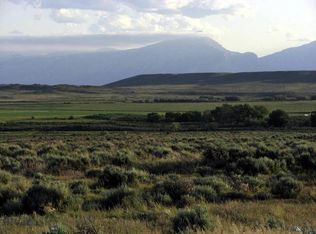
37.5 Acres of western vistas at the foot of the Beartooth Mountains only a mile off the state highway. Are you looking for your escape from the city lights and hectic pace of urban living? These 37.5 acres offer privacy and breathtaking views. Situated a little over 2 miles south of the Montana state line in Wyoming the land has numerous options for building sites with huge views of the Beartooth and Absaroka Mountains. Located 35 miles north of Cody, 30 miles northwest of Powell, Wyoming, 15 miles from Belfry, Montana (pop 220). You would be about 70 miles southwest of Billings & 30 miles from Red Lodge (pop 2500). Power is along Brushland Drive. Wildlife here includes mule deer, antelope, whitetails and occasionally elk, as well as coyotes, bobcats, hungarian partridge, sage grouse and pheasants. 90 miles from Yellowstone National Park via Cody or the Cooke City, Montana. Great area for peace & quiet... build a 2nd home, retire or even relocate. Lots of sun, very little snow. The Clark's Fork of the Yellowstone River is 6 miles to the west & offers some great fishing. Mild covenants, no HOA. The owner will consider owner financing with a large down. Call for details.
Sold on 05/23/25
Price Unknown
Tbd Brushland Dr, Powell, WY 82435
--beds
--baths
37.5Acres
Unimproved Land
Built in ----
37.5 Acres Lot
$-- Zestimate®
$--/sqft
$-- Estimated rent
Home value
Not available
Estimated sales range
Not available
Not available
Zestimate® history
Loading...
Owner options
Explore your selling options
What's special
Zillow last checked: 8 hours ago
Listing updated: May 26, 2025 at 04:06pm
Listed by:
Dean Petty 406-580-3372,
Mountainlands of MT Realty
Bought with:
Non Member
Non-Member Office
Source: Big Sky Country MLS,MLS#: 391633Originating MLS: Big Sky Country MLS
Facts & features
Interior
Interior area
- Finished area above ground: 0
Property
Features
- Has view: Yes
- View description: Farmland, Mountain(s), Southern Exposure, Valley
- Waterfront features: None
Lot
- Size: 37.50 Acres
- Features: Rolling Slope
- Topography: Rolling,Rough,Sloping
Details
- Additional parcels included: Geo Code: 1103580103414002
- Parcel number: R0028193
- Zoning description: AR - Agricultural & Rural Residential
- Special conditions: Standard
Utilities & green energy
- Utilities for property: Electricity Available, Natural Gas Not Available
Community & neighborhood
Location
- Region: Powell
- Subdivision: Other
Other
Other facts
- Listing terms: Cash,Contract,Owner May Carry,3rd Party Financing
- Road surface type: Dirt, Gravel
Price history
| Date | Event | Price |
|---|---|---|
| 5/23/2025 | Sold | -- |
Source: Big Sky Country MLS #391633 | ||
| 4/29/2025 | Pending sale | $108,900 |
Source: Big Sky Country MLS #391633 | ||
| 3/25/2025 | Listed for sale | $108,900 |
Source: Big Sky Country MLS #391633 | ||
| 3/16/2025 | Contingent | $108,900 |
Source: Big Sky Country MLS #391633 | ||
| 10/24/2024 | Listed for sale | $108,900 |
Source: Big Sky Country MLS #391633 | ||
Public tax history
Tax history is unavailable.
Neighborhood: 82435
Nearby schools
GreatSchools rating
- NAClark Elementary SchoolGrades: K-5Distance: 8.3 mi
- 8/10Powell Middle SchoolGrades: 6-8Distance: 20 mi
- 8/10Powell High SchoolGrades: 9-12Distance: 20.2 mi