Climate Change and Homes: Who Would Lose the Most to a Rising Tide?
Nationally, 1.9 million homes are projected to be literally underwater by the year 2100 if the oceans rise six feet. Thirty-nine percent are valued in the top third of homes in their metros, representing the potential loss of $597 billion in high-end real estate. A third (32 percent) are in the bottom tier of home values in their metros, amounting to a potential $123 billion loss for low-income homeowners.
- One-third (32 percent) of underwater homes would be valued in the bottom third nationally, meaning $123 billion in losses.
- Two in five (39 percent) underwater homes would be valued in the top third nationally, translating to $597 billion in lost high-end real estate.
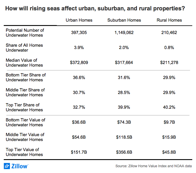
- In rural and suburban areas, homes in the top value tier may face particular risk, while in urban areas homes in the bottom value tier are more likely to be affected.
While the damage caused by recent hurricanes is a devastating reminder of how quickly the weather can undo people’s lives and destroy their homes, the potential for damage from a slower-moving phenomenon could be even more destructive: Rising sea levels.
Building on our 2016 analysis of the impact a rising tide could have on U.S. homes, we looked again at how many homes might be underwater by the end of the century — and whether those homes are in the top, middle or bottom tier in their areas. We also calculated the share in urban, suburban and rural areas.
Nationally, 1.9 million homes[1] are projected to be literally underwater by the year 2100 if the oceans rise six feet – roughly midway between the high end of what the government (considered a conservative source) says is “very likely” (4.3 feet) and the possibility of an 8-foot or greater rise than “cannot be excluded.” That accounts for 1.8 percent of the country’s total housing stock with a value of $916 billion, up from $882 billion in 2016. (To be clear, sea levels are not expected to rise uniformly, but we chose a midpoint rather than differentiating sea level predictions for different coastal areas.)

Although 39 percent of homes projected to be underwater are valued in the top third of homes in their metros – representing the potential loss of $597 billion in high-end real estate over the course of a single lifetime –not all of the underwater homes would be waterfront mansions: A third (32 percent) are in the bottom tier of home values in their metros, amounting to a potential $123 billion loss.
While wealthier homeowners may have more to lose in dollars, this scenario could be especially catastrophic for owners of the lowest-valued homes, because lower-income Americans spend a disproportionately large share of their earnings on mortgage payments. For these homeowners in particular, to lose their homes would mean to watch much of their lifetime earnings and overall wealth disappear.
Many of the metro areas that stand to lose the most property are clustered in Florida and along the East Coast. In the Miami metro alone, the losses are projected to total $30 billion for the owners of lower-end homes, $46 billion for homes valued in the middle tier, and a whopping $140 billion for high-end homeowners. In Houston, nearly 24,000 homes could be lost, 31 percent of which are owned by lower-income homeowners.
Some cities already are sinking millions of dollars into defense systems against this impending high tide, including a massive pump system in Miami Beach and a 10-foot steel-and-concrete wall around lower Manhattan. While these measures can help protect the investments of city dwellers, property owners in areas without as much money and in some suburban and rural areas may bear the costs of climate change themselves.
In fact, a majority (1.1 million) of potentially underwater homes are located in suburban ZIP codes, amounting to $549 billion in potential lost value, compared to $243 billion in urban areas and $71 billion in rural zip codes. Top valued homes are particularly likely to be affected in rural and suburban areas, while bottom tier homes face slightly more risk in urban areas.
Geographic highlights
States
- Florida stands to the lose the most property due to rising seas by a huge margin—908,183 homes lost, compared to only 180,110 in the state with the second-most underwater homes, New Jersey.
- In Oregon, over half (54 percent) of the at-risk homes are in the bottom value tier. In contrast, two-thirds (66 percent) of at-risk homes in Maine are in the top value tier.
Counties
- In Hyde County, N.C., only one in ten homes (9 percent) will be spared if sea levels rise by 6 feet.
- The median value of projected underwater homes in Nantucket County, Mass., is $2.2 million, which would total $1.8 billion in lost real estate across 618 homes.
Metros
- Four in five homes (83 percent) in the Key West, Fla., metro area will be underwater by the year 2100 if sea levels rise 6 feet.
- Nearly all at-risk homes (93 percent) in the Olympia, Wash., metro are in the top third of homes by value.
Cities
- Twenty-five coastal towns will be entirely submerged by the year 2100 if sea levels rise 6 feet.
- In Daytona Beach, Fla., the median value of 3,165 at-risk homes is $70,615, a potential catastrophe for low-income homebuyers.
ZIP codes
- The Malibu, Calif., ZIP code 90265 is home to the most expensive at-risk properties in the country, with a median value of $5.4 million across 247 properties.
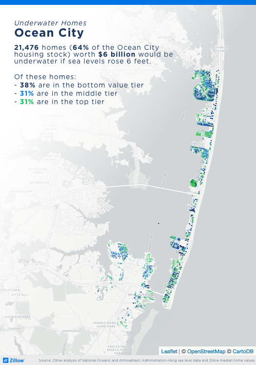
- The coastal Maryland ZIP code 21842, which contains Ocean City, is projected to lose more homes than any other ZIP code—22,384 properties, worth a combined $6.2 billion.
Automatically download data for all states, counties, metros, cities and ZIP codes.
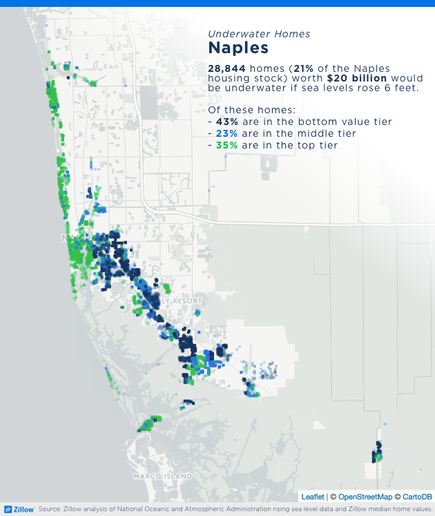
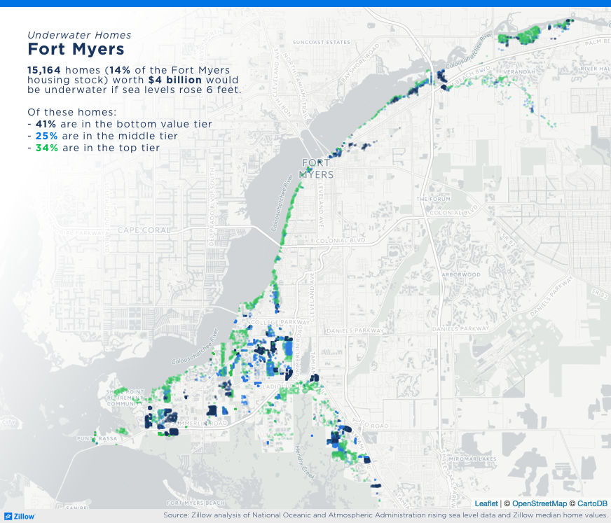
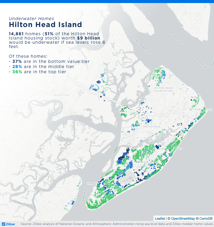
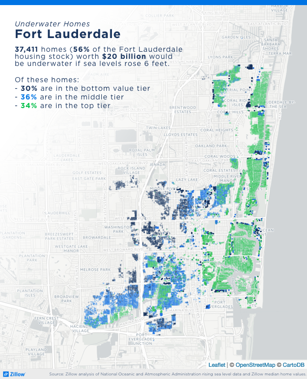
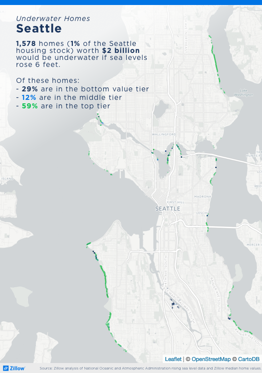
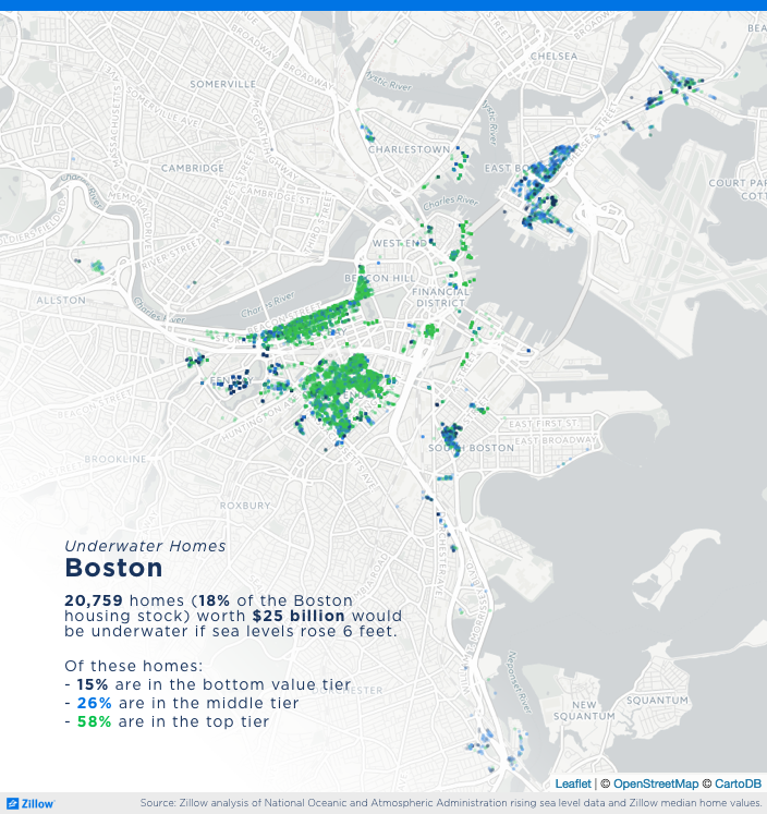
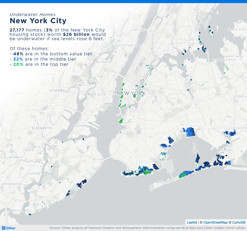
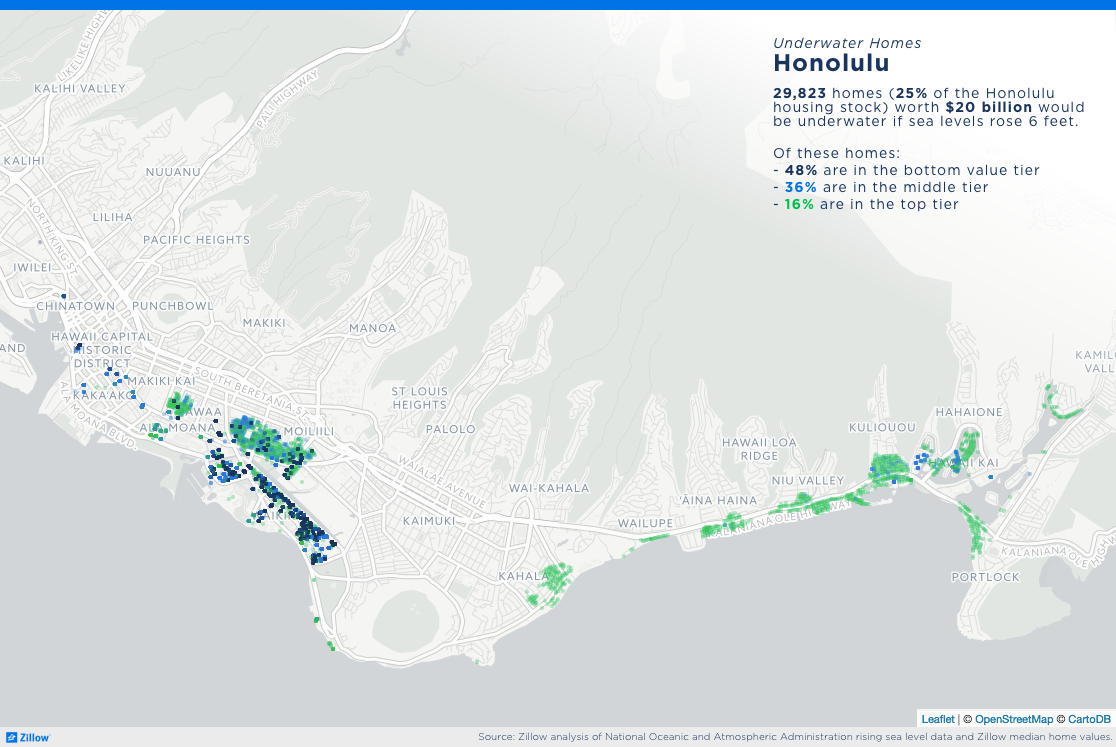
Here are close-up looks at the potential impact on particularly at-risk cities:
[1] These estimates do not include properties that were constructed after 2015.

