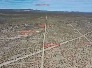
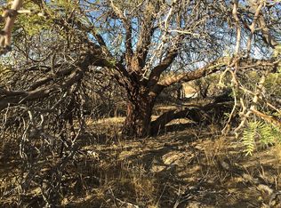
For sale by owner
  • Price cut: $550 (6/2)
    $29,950

    1 Excelsior Mine Rd, Nipton, CA 92364

    --beds
    0baths
    17Acres
    : 
    VacantLand
    Built in ----
    17 Acres Lot
    $-- Zestimate®
    $--/sqft
    $-- HOA

    What's special

    Good dirt road
    $29,950 CASH - 17.2 ACRES (#216) NIPTON, SAN BERNARDINO COUNTY, CA PERFECT FOR TARGET SHOOTING, CAMPING & RIDING YOUR OHV. This is a rare opportunity to own 17.2 acres adjacent to the Mojave National Preserve. There is a cleared campsite on the property to park your RV. There is a small hill on the west end of the property that makes a good backstop for target shooting. This 17.2 acres is 0.66 miles west of paved Excelsior Mine Road via a good dirt road. It is 2.25 miles northwest of the Cima Road interchange with the I-15 Freeway (see Google Earth aerials). The Cima Shell gas station and convenience store is at the I-15 interchange. Construction of the new Brightline West High-Speed Rail project connecting Southern California to Las Vegas has started along the I-15 Freeway. The adjacent 1.6 million acre Mojave National Preserve has miles of roads and Jeep trails to explore. Historic Valley Wells is one mile to the east. The scenic Clark Mountains are 7.5 miles to the northeast. This 17.2 acre parcel is 50 miles south of Las Vegas, NV, 20 miles south of Primm, NV and 80 miles north of Barstow, CA. The historic town of Nipton is 25 miles to the northeast. The property is an hour drive from the Las Vegas Strip. You take I-15 south through Mountain Pass to the Cima Road interchange. You travel 1.8 miles north on Cima Road which becomes Excelsior Mine Road. You then travel 0.66 miles northwest on BLM Open Route NN376 to eastern edge of the 17.2 acres. The cleared campsite is on the northwest portion of the property. The parcel has RC (resource conservation) zoning that permits one home or camping use. There is no electric or developed source of water to the parcel. The San Bernardino County Assessor parcel number is 0572-321-32. The parcel measures 715 + feet by 1,046 + feet containing 17.2123 acres. The buyer should contact San Bernardino County to investigate all zoning and development issues for the parcel. The 3 Google Earth aerial photographs show the access route from the I-15 Freeway via Cima/Excelsior Mine Road. The GPS coordinates for the northeast property corner are 35.469839, -115.701129. Just copy and paste these coordinates into Google Maps using your web browser and/or put these coordinates in the Google Maps App on your smart phone and navigate to the property. You can zoom in or out using map view or satellite view to see the surrounding area. Or, see my listing of this 17.2 acres with a drone video on LandSearch.com at land.ws/4403856. CASH SALE: You can purchase this parcel for $29,950 cash. The buyer and seller will each pay 50% of escrow fees and closing costs. The seller will pay for title insurance. We can open escrow as soon as I accept your offer. You will receive a deed to the property upon close of escrow. This property is sold “as is” with no warranties given by the seller. The buyer should do their own investigation to determine if this property is suitable for their particular usage or purpose. The sale is final with no refunds for any reason.
    99 days
    on Zillow
    |
    394
    |
    23
    |
    • Loading