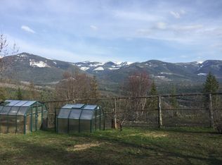
20 surveyed acres with large 67x78 steel beam constructed shop, underground INSTALLED POWER with meter, Stunning Mountain Range Views and borders 640 acres of State Land on one side and 80 acres of timber lands on the 2nd side. The shop has installed power, fixtures, concrete floor and three installed garage doors: one 16 x 14 and two 10 x 10. Located northeast of Sandpoint and first time on the market! Zoned Ag/Forestry 10 with the potential to be split into two 10-acre parcels. Conex box, metal shelving RV included. Endless recreational opportunities, the state land leads to timber land and 1,000’s of acres of US National Forest to explore! North Idaho with fresh air & 20 acres to call your own. NO CCR's or HOA fees. Sandpoint a Ski Mountain & Lake Community with stunning natural beauty and year-round recreation! World-class Schweitzer Ski resort for winter sports, a wealth of Forest Service lands or grab your fishing pole & head out to the big lake for a day of fun & sun on the water. Owner may finance with large down.
Sold
Price Unknown
1572 Cohage Rd, Sandpoint, ID 83864
--beds
--baths
20Acres
Unimproved Land
Built in ----
20 Acres Lot
$-- Zestimate®
$--/sqft
$-- Estimated rent
Home value
Not available
Estimated sales range
Not available
Not available
Zestimate® history
Loading...
Owner options
List your home for rent
Find your next renter with Zillow Rental Manager. Plus, with online applications, you can quickly screen prospective tenants – for free.
Learn moreRefinance and save
Refinancing to a lower rate could help reduce your monthly payments and save thousands over the life of the loan.
See today's ratesExplore your selling options
Work with a Zillow partner agent
Leverage their expertise and Zillow's premium Showcase listings to get your home seen by more buyers.
Get startedList with your own agent
Get your home in front of millions of buyers by listing it on Zillow.
Learn how to do itSell it yourself
Take full control of how buyers see your home on Zillow by listing For Sale by Owner (FSBO).
List your homeWhat's special
Zillow last checked: 7 hours ago
Listing updated: December 12, 2025 at 07:48am
Listed by:
Charesse Moore 208-255-6060,
EVERGREEN REALTY
Bought with:
Todd Savage, DB34890
STRATEGIC RELOCATION
Source: SELMLS,MLS#: 20252100
Facts & features
Property
Features
- Has view: Yes
- View description: Mountain(s), Panoramic
- Frontage length: 1338
Lot
- Size: 20 Acres
- Dimensions: 1338 x 662
- Features: 10 to 15 Miles to City/Town, 1 or more miles to County Road, Sloped, Steep Slope, Surveyed, Wooded, Brdrs Pub. Land, Level, Rolling Slope, Mature Trees, Southern Exposure, Brdrs State Land
Details
- Additional structures: Workshop
- Parcel number: RP59N01E357200AA
- Zoning: Ag/Forest 10
- Zoning description: Ag / Forestry
Utilities & green energy
- Sewer: No Info
- Utilities for property: Electricity Connected, Natural Gas Not Available
Community & neighborhood
Location
- Region: Sandpoint
Other
Other facts
- Listing terms: Cash, Conventional, Contract
- Ownership: Fee Simple
Price history
| Date | Event | Price |
|---|---|---|
| 12/11/2025 | Sold | -- |
Source: | ||
| 11/22/2025 | Pending sale | $419,000 |
Source: | ||
| 8/6/2025 | Listed for sale | $419,000 |
Source: | ||
| 8/1/2025 | Listing removed | $419,000 |
Source: | ||
| 7/12/2025 | Price change | $419,000-1.4% |
Source: | ||
Public tax history
Tax history is unavailable.
Neighborhood: 83864
Nearby schools
GreatSchools rating
- 9/10Northside Elementary SchoolGrades: PK-6Distance: 7.9 mi
- 7/10Sandpoint Middle SchoolGrades: 7-8Distance: 16.6 mi
- 5/10Sandpoint High SchoolGrades: 7-12Distance: 16.7 mi
Schools provided by the listing agent
- Elementary: Northside
- Middle: Sandpoint
- High: Sandpoint
Source: SELMLS. This data may not be complete. We recommend contacting the local school district to confirm school assignments for this home.
- Idaho
- Bonner County
- Sandpoint
- 83864
- 1572 Cohage Rd