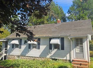
Two contiguous parcels totaling approximately 1.91 acres along Rock Spring Road in Forest Hill, offered together. The improved property at 1600 Rock Spring Road is identified as Tax Map 40, Parcel 214 and contains 37,897 square feet, or approximately 0.87 acre. The adjoining vacant lot has no assigned street address and is identified as Tax Map 40, Parcel 245, containing 1.04 acres with a legal description of approximately 104 feet by 427 feet. Both parcels are zoned R2 Urban Residential. An existing residence, well and septic system are located on the improved parcel. Public sewer infrastructure is nearby due to the property’s proximity to the adjoining apartment community; however, connection availability, capacity, costs and requirements must be independently verified with Harford County. The parcels are being sold together and as-is. Buyer is responsible for verifying acreage, zoning, permitted uses, development potential, access, utilities and site conditions. Please schedule an appointment before entering the property.
Lot/land
$799,990
1600 Rock Spring Rd, Forest Hill, MD 21050
--beds
--baths
0.87Acres
Unimproved Land
Built in ----
0.87 Acres Lot
$-- Zestimate®
$--/sqft
$-- HOA
What's special
Along rock spring road
- 42 days
- 42
- 0
Zillow last checked:
Listing updated:
Listed by:
Nicholas Badalian 443-253-5928,
Fathom Realty MD, LLC 8884556040
Source: Bright MLS,MLS#: MDHR2060126
Facts & features
Property
Features
- Has view: Yes
- View description: Trees/Woods
Lot
- Size: 0.87 Acres
Details
- Has additional parcels: Yes
- Parcel number: 1303041344
- Zoning: AG
- Special conditions: Standard
Utilities & green energy
- Sewer: On Site Septic
- Water: Well
Community & HOA
HOA
- Has HOA: No
Location
- Region: Forest Hill
Financial & listing details
- Tax assessed value: $291,067
- Annual tax amount: $3,172
- Date on market: 9/16/2026
- Listing agreement: Exclusive Right To Sell
- Listing terms: Cash,Bank Portfolio,Conventional,Negotiable,Other
- Ownership: Fee Simple
Estimated market value
Not available
Estimated sales range
Not available
Not available
Price history
| Date | Event | Price |
|---|---|---|
| 9/16/2026 | Listed for sale | $799,990+433.3% |
Source:  Bright MLS #MDHR2060126 Report a problem | ||
| 5/20/1998 | Sold | $150,000 |
Source: Public Record Report a problem | ||
Public tax history
| Year | Property taxes | Tax assessment |
|---|---|---|
| 2026 | $3,232 +2.5% | $291,067 +2.6% |
| 2025 | $3,152 +7.1% | $283,700 +5.1% |
| 2024 | $2,943 +5.3% | $270,033 +5.3% |
| 2023 | $2,794 +5.6% | $256,367 +5.6% |
| 2022 | $2,645 -3% | $242,700 +1.4% |
| 2021 | $2,727 +0.1% | $239,433 +1.4% |
| 2020 | $2,725 +1.4% | $236,167 +1.4% |
| 2019 | $2,688 +1.2% | $232,900 +1.2% |
| 2018 | $2,655 -1.2% | $230,100 -1.2% |
| 2017 | $2,688 | $232,900 +3.7% |
| 2016 | -- | $224,500 |
| 2015 | -- | $224,500 |
| 2014 | $2,759 | $224,500 -5.9% |
| 2013 | -- | $238,600 |
| 2012 | -- | $238,600 |
| 2011 | -- | $238,600 -15.5% |
| 2010 | -- | $282,460 +9.9% |
| 2009 | -- | $257,046 +7.4% |
| 2008 | -- | $239,350 +13.6% |
| 2007 | -- | $210,640 +10.1% |
| 2006 | -- | $191,376 +11.2% |
| 2005 | -- | $172,113 +12.6% |
| 2004 | -- | $152,850 +3.4% |
| 2003 | -- | $147,786 +3.5% |
| 2002 | -- | $142,723 +3.7% |
| 2001 | -- | $137,660 |
Find assessor info on the county website
Monthly payment
Climate risks
Neighborhood: 21050
Nearby schools
Schools provided by the listing agent
- District: Harford County Public Schools
Source: Bright MLS. This data may not be complete. We recommend contacting the local school district to confirm school assignments for this home.


Similar homes
- $515,00017.38 acres2614 Johnson Mill Rd, Forest Hill, MD 21050Lot/Land
 MLS ID #MDHR2060758, Aimee C O'Neill, O'Neill Enterprises Realty. Bright MLS
- $448,3339.65 acres2229 Ady Rd, Forest Hill, MD 21050Lot/Land
 MLS ID #MDHR2058820, Steve Kuzma, Weichert, Realtors - Diana Realty. Bright MLS
- $750,0001.15 acres1700 Conowingo Rd, Bel Air, MD 21014Lot/Land
 MLS ID #MDHR2030400, Chris Streett, Monument Sotheby's International Realty. Bright MLS
- $895,00044.3 acresPatterson Mill Rd, Bel Air, MD 21015Lot/Land
 MLS ID #MDHR2055318, Thomas Mooney, O'Conor, Mooney & Fitzgerald. Bright MLS
- $795,0004.61 acres734 Schofield Ave, Aberdeen, MD 21001Lot/LandMLS ID #MDHR2059500, Chad Tyler, Tyler Duncan Realty Partners, Inc.. Bright MLS
- $885,00026.29 acres7219 New Cut Rd, Kingsville, MD 21087Lot/LandMLS ID #MDBC2167920, Dennis Thomas, Next Step Realty. Bright MLS
- $425,0004.29 acres3620-3628 Sewell Rd, Abingdon, MD 21009Lot/LandMLS ID #MDHR2060874, Terry Berkeridge, Advance Realty USA INC. Bright MLS
- $549,90020.4 acres0 Madonna Rd, Jarrettsville, MD 21084Lot/LandMLS ID #MDHR2057022, Dustin Prievo, Whitetail Properties Real Estate, LLC. Bright MLS
- $400,00018.78 acres17348 Troyer Rd, Monkton, MD 21111Lot/LandMLS ID #MDBC2145826, Harry Henderson, O'Conor, Mooney & Fitzgerald. Bright MLS
- $539,0003.48 acresPoplar Hill Rd, Phoenix, MD 21131Lot/LandMLS ID #MDBC2170832, Lauren Dahdah, Monument Sotheby's International Realty. Bright MLS
- $799,0001.35 acres4 Hayfields Ct, Cockeysville, MD 21030Lot/LandMLS ID #MDBC2077272, Heidi Krauss, Krauss Real Property Brokerage. Bright MLS
- $599,0003.01 acres14490 Western Rd, Sparks Glencoe, MD 21152Lot/LandMLS ID #MDBC2140236, Heidi Krauss, Krauss Real Property Brokerage. Bright MLS
- $400,00011.15 acresBowleys Quarters Rd, Middle River, MD 21220Lot/LandMLS ID #MDBC2145042, Juna Korreta, Monument Sotheby's International Realty. Bright MLS
- $399,9990.84 acresDays Cove Rd, White Marsh, MD 21162Lot/LandMLS ID #MDBC2156934, Jennifer Drennan, Taylor Properties. Bright MLS
- $599,0002.99 acres14498 Western Rd, Sparks Glencoe, MD 21152Lot/LandMLS ID #MDBC2140240, Heidi Krauss, Krauss Real Property Brokerage. Bright MLS
- $1,198,0006 acres14498 Western Rd #2, Sparks Glencoe, MD 21152Lot/LandMLS ID #MDBC2141866, Heidi Krauss, Krauss Real Property Brokerage. Bright MLS
- $699,00013.69 acres13036 Jerome Jay Dr, Cockeysville, MD 21030Lot/LandMLS ID #MDBC2116636, Norman Domingo, XRealty.NET LLC. Bright MLS
- $1,050,0000.99 acresWarren Rd, Cockeysville, MD 21030Lot/LandMLS ID #MDBC2071346, Lisa Alatis-Hapney, Samson Properties. Bright MLS
- $499,0001.47 acres6580 Loch Raven Blvd, Baltimore, MD 21239Lot/LandMLS ID #MDBC2152046, Katie Fones, Monument Sotheby's International Realty. Bright MLS
