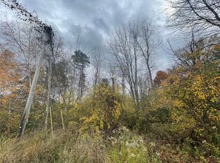
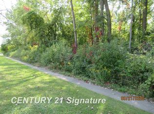
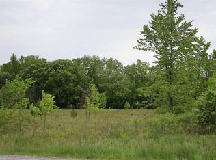
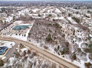
For farmers or potential developers. 8.34 acres on Curtis and Fort Roads, just a few minutes outside of Bridgeport where there's access to Dixie Highway and I-75. Located in a rural portion of Bridgeport Township, several single family homes already line the road with city water at the street. For farmers, the ground is a sandy loam and is not planted for 2025.
Lot/land
$99,900
Fort Rd, Birch Run, MI 48415
--beds
--baths
8.34Acres
Land
Built in ----
8.34 Acres Lot
$-- Zestimate®
$--/sqft
$-- HOA
What's special
- 305 days |
- 198 |
- 20 |
Zillow last checked: 7 hours ago
Listing updated: November 25, 2025 at 06:11am
Listed by:
Andrew J Keller 810-444-2963,
Knockout Real Estate 989-718-9058
Source: Realcomp II,MLS#: 20251004875
Facts & features
Interior
Features
- Has basement: No
- Has fireplace: No
Property
Lot
- Size: 8.34 Acres
- Dimensions: 884 x 409
- Features: Cleared, Farm, Level, Split Possible
Details
- Parcel number: 09115284003006
- Zoning description: Agricultural
- Special conditions: Short Sale No,Standard
Utilities & green energy
- Sewer: Septic Needed
- Water: None
Community & HOA
HOA
- Has HOA: No
Location
- Region: Birch Run
Financial & listing details
- Tax assessed value: $21,300
- Annual tax amount: $541
- Date on market: 6/5/2025
- Cumulative days on market: 305 days
- Listing agreement: Exclusive Right To Sell
- Listing terms: Cash,Conventional
Estimated market value
Not available
Estimated sales range
Not available
$1,128/mo
Price history
Price history
| Date | Event | Price |
|---|---|---|
| 6/5/2025 | Listed for sale | $99,900+233% |
Source: | ||
| 1/31/2014 | Sold | $30,000-40% |
Source: Public Record Report a problem | ||
| 9/15/2010 | Sold | $50,000 |
Source: Public Record Report a problem | ||
Public tax history
Public tax history
| Year | Property taxes | Tax assessment |
|---|---|---|
| 2024 | $426 +217% | $18,300 +12.3% |
| 2023 | $134 | $16,300 +11.6% |
| 2022 | -- | $14,600 +9.8% |
| 2021 | $481 | $13,300 +13.7% |
| 2020 | $481 +23.4% | $11,700 -3.3% |
| 2018 | $390 -55.7% | $12,100 -12.3% |
| 2017 | $880 | $13,800 |
| 2016 | $880 | $13,800 -16.4% |
| 2014 | $880 | $16,500 |
| 2013 | -- | $16,500 -12.2% |
| 2011 | -- | $18,800 -4.1% |
| 2010 | -- | $19,600 |
| 2009 | -- | $19,600 -4.9% |
| 2008 | -- | $20,600 +2% |
| 2007 | -- | $20,200 +5.2% |
| 2006 | -- | $19,200 |
| 2005 | -- | $19,200 |
| 2003 | -- | $19,200 +23.1% |
| 2002 | -- | $15,600 +11.4% |
| 2001 | -- | $14,000 +6.1% |
| 2000 | -- | $13,200 |
Find assessor info on the county website
Monthly payment
Estimated monthly payment
All calculations are estimates and provided by Zillow, Inc. for informational purposes only. Actual amounts may vary.
HOA fees may include property taxes on listings classified as Co-Ops. Contact the listing agent and/or owner for fee details.
Mortgage interest rates are dependent on a number of factors, including credit score, down payment, and repayment length. Interest rate data provided by Zillow Group Marketplace, Inc. as of 1/1/1970 from various mortgage lenders with which we have lead or other similar arrangements; the Estimated Payment is an average of those rates.
See how much you could borrow to make a competitive offer.
Climate risks
Neighborhood: 48415
Nearby schools
GreatSchools rating
- NAThomas White SchoolGrades: PK-1Distance: 3.4 mi
- 5/10Bridgeport-Spaulding Middle School-SchrahGrades: 6-8Distance: 3.5 mi
- 3/10Bridgeport High SchoolGrades: 9-12Distance: 2.4 mi
Local experts in 48415


Nearby cities
Nearby zip codes
Other Birch Run Topics
