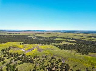
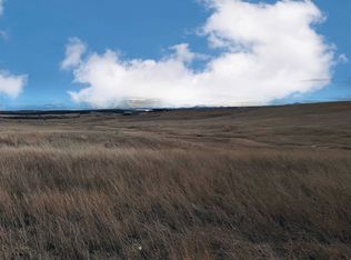
A secluded 19.29-acre timber sanctuary fronting Majestic View Road, a county-maintained gravel road, in Crook County, Wyoming, on the pine-clad northern edge of the Black Hills. Dense Ponderosa pine and oak blanket roughly 90 percent of the parcel, broken by rocky outcroppings and sunlit openings, with a dramatic 137 feet of relief. Perimeter-fenced within the combined 40.76-acre holding. A sportsman's retreat or dream homesite high in the pines.Roughly triangular in shape, the parcel runs on a northwest-to-southeast axis with direct frontage along Majestic View Road on the eastern boundary, and a Larson Ridge Trail intersection provides a second point of access from the east. The ground rises 136.9 feet across the tract, climbing from 3,450.2 feet at the lower southern edge to a 3,587.2-foot high point in the northwest, and that vertical relief is what gives the property its layered, big-country character. Average slope is 14 percent, ranging from gentle 1.3 percent benches near the road frontage to steep 36.6 percent pitches on the upper reaches. The most practical building ground lies in the gentler zones along Majestic View Road and on the accessible benches through the mid-slope, where a home could be tucked into the pines with elevation and privacy on every side. The parcel lies entirely outside mapped Federal Emergency Management Agency (FEMA) flood hazard zones, with no 100-year or 500-year flood risk within any portion of its boundaries, a meaningful distinction in this broken terrain. No permanent structures are present on the parcel. Perimeter fencing runs around the exterior boundary of the available combined 40.76-acre holding; the interior boundary between this parcel and the adjacent Mona Road tract is not separately fenced. Development of this parcel as a standalone unit will require timber clearing for any building pad, a Wyoming State Engineer's Office well permit or arrangement for a shared water source, an engineered septic system, and electrical extension. A buyer purchasing the combined 40.76-acre holding will benefit from electric service and shared well access already established at the Mona Road parcel to the south. Heavy Ponderosa pine and oak timber over broken, rising ground gives this parcel the kind of cover and structure that serious wildlife country is built on. Roughly 90 percent canopy, rocky outcroppings, and 137 feet of relief across less than 20 acres create bedding, travel, and escape terrain within a compact footprint, the sort of secluded timber that holds game rather than simply passing it through. That habitat supports whitetail deer, mule deer, and wild turkey, and elk are a realistic possibility given the parcel's seclusion and its proximity to the Black Hills National Forest and the herds that range the Bear Lodge Mountains. The interplay of dense timber and small natural openings gives a hunter both cover to move and edges to watch. Hunting opportunity is subject to Wyoming Game and Fish Department seasons and licensing. Beyond the hunt, the timber canopy, topographic variation, and quiet lend themselves to hiking, shed antler hunting, wildlife photography, camping, and dark-sky nights well removed from town light. The Larson Ridge Trail intersection on the eastern boundary provides built-in recreational access, and Majestic View Road frontage keeps the tract reachable year-round. Purchased together with the adjacent Mona Road parcel, the holding also gains the seasonal creek in that tract's southwest corner, adding a genuine water element and rounding out a 40.76-acre recreational base. Devils Tower National Monument, the Bearlodge Ranger District of the Black Hills National Forest, and the broader public-land network of the northern Wyoming Black Hills all lie within a short drive. No documented streams, ponds, wetlands, or water rights exist within this parcel's boundaries. No FEMA flood hazard zones are mapped within the property. A private well permit from the Wyoming State Engineer's Office will be required for standalone development of this tract. A buyer acquiring the combined 40.76-acre holding will benefit from shared well access established at the Mona Road parcel immediately to the south. Standing Ponderosa pine and oak represent the primary natural resource; no timber cruise has been conducted. Mineral rights status is unknown and should be confirmed through a title commitment prior to closing. Crook County occupies the northeastern corner of Wyoming, bounded by South Dakota to the east and Montana to the north, where the open high plains climb into the timbered country of the Black Hills and the Bear Lodge Mountains. This parcel sits on that northern fringe, in one of the more remote and thinly settled corners of the region, where rolling, pine-clad hills give a sense of scale and solitude increasingly rare in the Black Hills recreational market. The climate is semi-arid continental with four distinct seasons. Winters are cold but frequently open, with snow coming and going from October into April rather than lying deep, summers are warm and dry with cool evenings, and spring green-up transforms the hills. Annual precipitation averages roughly 15 to 20 inches, most of it arriving as spring and early-summer rain. The dry, mild summers are well suited to camping, building, and outdoor recreation. Ownership costs match the setting. Wyoming levies no state personal income tax, and Crook County's low mill levy keeps recreational land among the least expensive to hold in the Black Hills, with annual taxes on this parcel estimated at $680. Landmarks are close at hand: Devils Tower National Monument lies roughly 35 miles by road to the west via Wyoming Highway 24, and the trails, forests, and lakes of the northern Black Hills are within an easy drive. Crook County takes its name from General George Crook, who conducted military campaigns through northeastern Wyoming during the 1876 Great Sioux War. The discovery of gold during General Custer's 1874 expedition triggered a rush of settlement that reshaped the region within a generation. Northeastern Wyoming was homesteaded in the late 19th century as cattlemen and small farmers pushed into the grasslands and timber foothills surrounding the Black Hills. The community of Aladdin, established in the 1880s, remains one of the most distinctive rural outposts in Wyoming. Aladdin's general store, in continuous operation since 1896, is recognized as one of the oldest operating general stores in the state and serves as a community gathering point for ranchers and visitors alike. The property is accessed via Majestic View Rd, just off Mona Road (CR 222), a county-maintained gravel road providing year-round access. Aladdin, Wyoming is approximately 7 to 9 miles to the south, offering minimal local services. Sundance, Wyoming, the Crook County seat, is approximately 30 miles south via Wyoming Highway 111 and provides basic retail, fuel, medical, and county government services. Belle Fourche, South Dakota is approximately 25 to 30 miles east. Spearfish, South Dakota is approximately 40 miles southeast, offering expanded retail, dining, and medical options. Rapid City, South Dakota is approximately 90 miles southeast and provides regional airport access, major medical facilities, and full commercial services. Devils Tower National Monument is approximately 35 miles west via Wyoming Highway 24.
Lot/land
$124,000
Majestic View Rd, Aladdin, WY 82710
0beds
0baths
19.29Acres
Unimproved Land
Built in ----
19.29 Acres Lot
$-- Zestimate®
$--/sqft
$-- HOA
What's special
Fronting majestic view road
- 48 days
- 2,033
- 212
Zillow last checked:
Listing updated:
Listed by:
Kerry Engelmann 605-484-4325,
Hayden Outdoors Real Estate
Source: NY State MLS,MLS#: 11906706
Facts & features
Interior
Bedrooms & bathrooms
- Bedrooms: 0
- Bathrooms: 0
Features
- Has basement: No
- Has fireplace: No
Interior area
- Total structure area: 0
- Finished area above ground: 0
Property
Features
- Frontage length: 0
Lot
- Size: 19.29 Acres
Details
- Lease amount: $0
Community & HOA
HOA
- Has HOA: No
Location
- Region: Aladdin
Financial & listing details
- Date on market: 7/28/2026
- Date available: 07/01/2026
- Listing agreement: Exclusive
Estimated market value
Not available
Estimated sales range
Not available
Not available
Price history
| Date | Event | Price |
|---|---|---|
| 7/28/2026 | Listed for sale | $124,000 |
Source: NY State MLS #11906706 Report a problem | ||
Public tax history
Tax history is unavailable.
Monthly payment
Climate risks
Neighborhood: 82710
Nearby schools
Schools provided by the listing agent
- District: 000000
Source: NY State MLS. This data may not be complete. We recommend contacting the local school district to confirm school assignments for this home.

Similar homes
- $175,0009.92 acresLOT 39 Halle Rae Ln, Belle Fourche, SD 57717Lot/Land
 MLS ID #90051, Cathy Buckmaster. Mount Rushmore Area AOR
 - $175,0008.85 acresLOT 37 Halle Rae Ln, Belle Fourche, SD 57717Lot/Land
 MLS ID #90050, Cathy Buckmaster. Mount Rushmore Area AOR
 - $165,0007.54 acresRobinson Rd, Belle Fourche, SD 57717Lot/Land
 MLS ID #89776, Jeb T Hughes. Mount Rushmore Area AOR
 - $135,00010.06 acresLOT 12 Belle View Dr, Belle Fourche, SD 57717Lot/Land
 MLS ID #86924, Traci Nowowiejski. Mount Rushmore Area AOR
