- Press Releases
Sustainability
Social Impact
Explore how Zillow is driving real progress toward a more affordable and accessible housing market.
- Investors
- Careers
5 min read
Capturing SkyTour: How structured drone capture powers immersive 3D
Zillow Media Experts, real-time feedback and AI modeling work together in the field
Written by Zillow on March 16, 2026
Edited by Matthew Deering and Will Hutchcroft and Matthew Radovan and Sean Cier
When we set out to bring SkyTour to life, we weren’t just building a new feature. We were pioneering an industry-first capture process that relies on quality at every step. What sets SkyTour apart isn’t just the technology — it’s the people behind it.
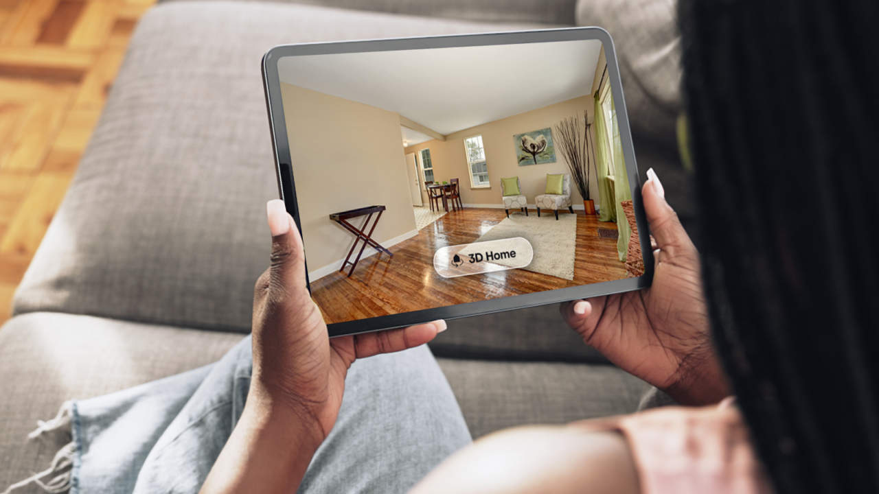
The footage captured in the field becomes the foundation for SkyTour’s AI engine, where Structure-from-Motion and 3D Gaussian Splatting (3DGS) transform imagery into a volumetric model. That trained model is then rendered through a navigation model that keeps the home at the center of the experience, enabling buyers to explore each property interactively. Designing capture meant designing for the entire system — ensuring decisions made in the field translate seamlessly into reconstruction and the final experience.
Because 3DGS synthesizes new views from real imagery, it performs best when desired viewpoints are close to actual captured frames. While 3DGS can generate novel views, it depends on consistent, comprehensive coverage of the scene. Early testing showed that delivering a strong user experience depends on capturing the home from viewpoints that closely match how people will explore it.
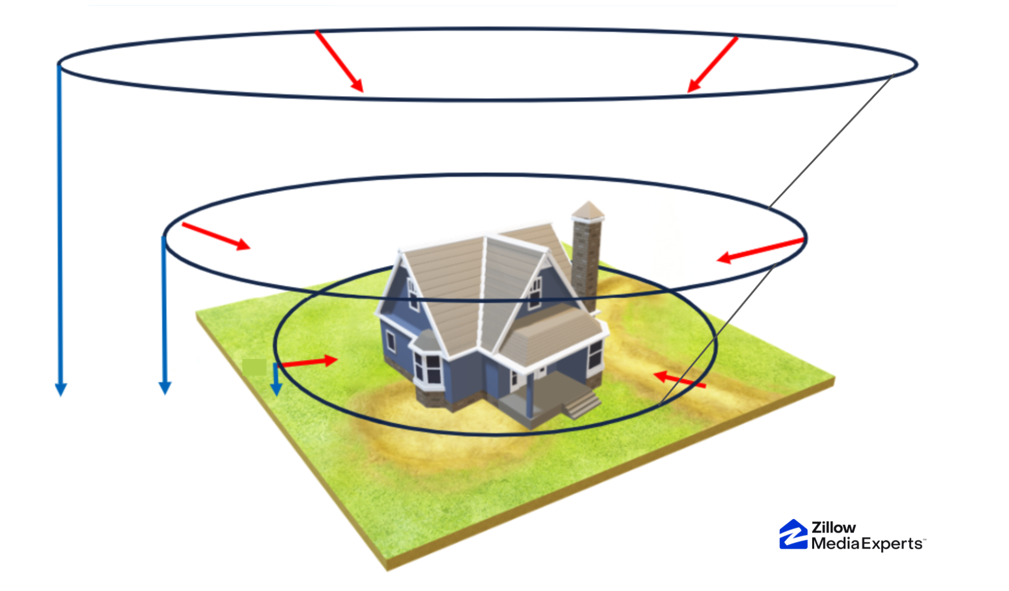
Capturing the home from every critical angle
After designing the interactive viewing experience, we crafted a structured flight plan to match. The core of our methodology is a slow, steady set of orbits at multiple elevations, with camera settings set to minimize blur.
This approach effectively covers the viewing volume with high-quality source imagery.
By holding consistent flight characteristics and centering the home, we generate comprehensive coverage and sufficient diversity of viewpoints to provide the spatial constraints required for a geometrically sound splat model.
A single continuous video provides a clear, unbroken signal that allows us to precisely reconstruct the drone’s flight path. Those views are then combined into a seamless 3D space.
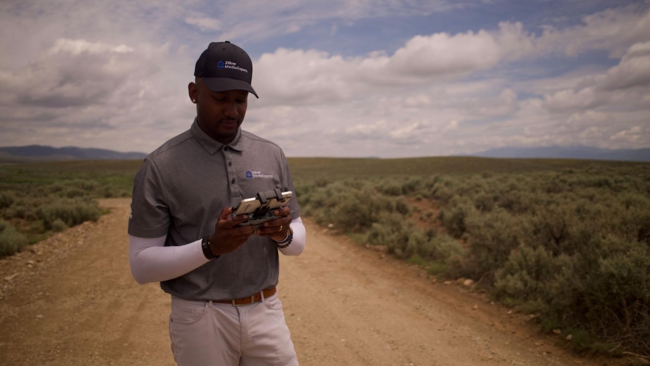
Scaling this methodology from early tests to more than 300 pilots required a new mindset. Drone photography often encourages creative freedom, but SkyTour depends on structured procedural capture. We introduced training that emphasized consistency in orbit structure, velocity and framing. Once photographers saw how this framework minimized 3DGS artifacts, reduced missing coverage and improved fidelity, they embraced it.
Capture isn’t an isolated operational step. It’s the first stage of an integrated AI system, where decisions in the field directly influence model quality and user experience.
Navigating obstacles and ensuring compliance
Every property presents unique challenges. Trees, power lines, neighboring structures and environmental barriers require judgment and adaptability. Balancing a prescribed capture process with the flexibility to adapt to real-world conditions is one of the most complex aspects of operationalizing SkyTour.
Lessons from beta testing informed situational training, including obstacle avoidance, environmental adjustments and neighbor de-escalation. Our pilots must be confident in their decision-making and supported in making the right call in the field. Continuous communication, shared feedback and iterative improvement have helped refine flying techniques across the network.
Because the Zillow Media Experts team had already provided a variety of drone-based services, we began with a strong foundation in FAA compliance and flight safety. In areas where SkyTour isn’t possible due to federal or local regulations — such as airspace ceilings below 100 feet, temporary flight restrictions (TFRs) or no-fly zones — our Customer Service and Media Fulfillment teams coordinate directly with clients.
Operational discipline ensures that structured capture can scale responsibly across diverse environments.
Delivering real-time feedback in the field
Coverage and viewpoint diversity are essential for high-quality 3DGS reconstruction. Early on, photographers relied primarily on their phone’s live video viewfinder during capture. However, because final 3DGS generation is computationally intensive, they would not know whether coverage was sufficient until hours after leaving the site.
To provide more immediate insight, we developed two complementary feedback systems.
First, we use GPS and altitude data recorded during video capture. By analyzing several hundred SkyTours, we parameterized flight paths against an abstract orbital model and evaluated resulting quality to design a capture path checklist. During new captures, flight paths are parameterized and compared against this model, helping photographers stay within an optimal range during orbit.
Second, we built a preview system based on photogrammetry. By decimating captured video and generating a low-fidelity textured mesh on device, we quickly compute a representation of the home immediately after capture. Photogrammetry provides both geometry and pose data — the location and viewing angle of each image used to construct the model.
For each face in the mesh, we compute visual coverage based on the number of poses in which that face is visible. We then layer this scalar field onto the texture map, highlighting areas with insufficient coverage using a visual pattern that photographers can quickly interpret. If needed, they can perform additional passes before leaving the property.
This shift moved capture from a film-camera model to a digital-camera model, giving photographers visibility into how flight decisions translate into the final 3D scene.
Integrating human expertise at every stage
Even with structured capture and AI-driven reconstruction, human oversight remains essential. Zillow annotators review every SkyTour before delivery, identify errors, and collaborate with regional managers to improve performance. For some homes, foliage or structures prevent the drone pilot from capturing parts of the lower orbit at a high quality, and in those cases the annotation team can modify the extents of the view cone to compensate. Where environments make capture difficult or impossible, we provide reshoot and refund processes to ensure quality and client satisfaction.
From structured flight paths to real-time feedback and final review, the decisions made in the field ripple forward to shape reconstruction fidelity and enable the smooth, interactive exploration buyers experience when they launch a SkyTour.
SkyTour represents a coordinated system in which skilled professionals and AI-powered reconstruction work together across capture, production and display — expanding what it means to understand a home before ever stepping inside.
This system reflects a deliberate approach to AI by pairing machine intelligence with human expertise and production infrastructure to reshape how real estate is experienced.
Related Articles


Sign up for Zillow news updates
Subscribe to receive daily emails for the latest Zillow news and announcements, product updates and more.
%20--%3e%3cdefs%3e%3cstyle%3e%20.st0%20{%20fill:%20%23111116;%20}%20%3c/style%3e%3c/defs%3e%3cpath%20class='st0'%20d='M.67,84.17v-9.38L39.19,20.75v-1.12H1.34V4.67h62.64v9.38l-37.85,54.04v1.12h38.97v14.96H.67Z'/%3e%3cpath%20class='st0'%20d='M75.04,9.36c0-5.58,4.13-9.71,9.94-9.71s9.94,4.13,9.94,9.71-4.13,9.71-9.94,9.71-9.94-4.02-9.94-9.71ZM76.71,84.17V27h16.53v57.17h-16.53Z'/%3e%3cpath%20class='st0'%20d='M106.3,84.17V1.32h16.53v82.85h-16.53Z'/%3e%3cpath%20class='st0'%20d='M135.33,84.17V1.32h16.53v82.85h-16.53Z'/%3e%3cpath%20class='st0'%20d='M161.79,55.58c0-18.42,12.62-30.37,31.71-30.37s31.71,11.95,31.71,30.37-12.73,30.37-31.71,30.37-31.71-11.95-31.71-30.37ZM208.58,55.58c0-9.49-6.25-16.19-15.07-16.19s-15.18,6.7-15.18,16.19,6.25,16.3,15.18,16.3,15.07-6.81,15.07-16.3Z'/%3e%3cpath%20class='st0'%20d='M246.32,84.17l-17.2-57.17h16.86l11.61,40.64h1.12l10.16-40.64h16.53l10.94,40.98h1.12l11.39-40.98h16.41l-17.31,57.17h-21.55l-8.71-37.85h-1.12l-8.6,37.85h-21.66Z'/%3e%3cpath%20class='st0'%20d='M362.44,84.17V4.67h56.94v15.86h-38.3v17.53h33.5v14.51h-33.5v31.6h-18.65Z'/%3e%3cpath%20class='st0'%20d='M428.76,84.17V27h16.3v7.82h1.23c2.46-5.36,8.04-8.93,14.07-8.93,2.34,0,4.69.56,6.48,1.45v14.85c-3.24-1.45-7.03-2.12-9.38-2.12-7.26,0-12.17,6.03-12.17,14.85v29.25h-16.53Z'/%3e%3cpath%20class='st0'%20d='M471.64,55.58c0-18.42,12.62-30.37,31.71-30.37s31.71,11.95,31.71,30.37-12.73,30.37-31.71,30.37-31.71-11.95-31.71-30.37ZM518.43,55.58c0-9.49-6.25-16.19-15.07-16.19s-15.18,6.7-15.18,16.19,6.25,16.3,15.18,16.3,15.07-6.81,15.07-16.3Z'/%3e%3cpath%20class='st0'%20d='M545.11,84.17V27h16.52v8.04h1.12c4.24-6.48,9.71-9.71,16.64-9.71,12.95,0,21.55,10.05,21.55,23.78v35.06h-16.52v-32.72c0-7.03-4.02-11.95-10.72-11.95s-12.06,5.25-12.06,12.51v32.16h-16.52Z'/%3e%3cpath%20class='st0'%20d='M617.13,65.74v-26.69h-8.04v-12.06h8.49l3.24-18.09h12.95l-.11,18.09h13.06v12.06h-13.06v26.02c0,4.8,2.9,8.04,7.59,8.04,1.56,0,4.02-.33,5.92-.78v11.84c-3.24,1.12-7.93,1.79-11.17,1.79-11.5,0-18.87-8.15-18.87-20.21Z'/%3e%3cpath%20class='st0'%20d='M686.58,84.17V4.67h34.95c19.43,0,31.93,10.27,31.82,26.69,0,16.3-12.62,26.8-31.93,26.8h-16.52v26.02h-18.31ZM704.89,44.08h15.07c9.16,0,14.85-5.02,14.85-12.73s-5.81-12.62-14.85-12.62h-15.07v25.35Z'/%3e%3cpath%20class='st0'%20d='M757.71,55.58c0-18.42,12.62-30.37,31.71-30.37s31.71,11.95,31.71,30.37-12.73,30.37-31.71,30.37-31.71-11.95-31.71-30.37ZM804.49,55.58c0-9.49-6.25-16.19-15.07-16.19s-15.19,6.7-15.19,16.19,6.25,16.3,15.19,16.3,15.07-6.81,15.07-16.3Z'/%3e%3cpath%20class='st0'%20d='M831.17,84.17V27h16.3v7.82h1.23c2.46-5.36,8.04-8.93,14.07-8.93,2.34,0,4.69.56,6.48,1.45v14.85c-3.24-1.45-7.03-2.12-9.38-2.12-7.26,0-12.17,6.03-12.17,14.85v29.25h-16.52Z'/%3e%3cpath%20class='st0'%20d='M874.16,55.58c0-18.2,12.62-30.37,31.04-30.37,15.52,0,27.36,8.71,29.25,22.22l-15.41,2.01c-1.45-6.25-7.26-10.61-13.62-10.61-8.37,0-14.74,6.92-14.74,16.75s6.25,16.75,14.63,16.75c6.59,0,12.17-4.35,13.73-10.5l15.52,1.9c-2.12,13.51-14.07,22.22-29.37,22.22-18.2,0-31.04-12.28-31.04-30.37Z'/%3e%3cpath%20class='st0'%20d='M944.73,84.17V1.32h16.52v33.39h1.12c4.35-6.25,9.71-9.49,16.64-9.49,12.95,0,21.66,10.05,21.66,23.67v35.28h-16.52v-32.83c0-7.03-4.13-11.95-10.83-11.95s-12.06,5.25-12.06,12.62v32.16h-16.52Z'/%3e%3c/svg%3e)
