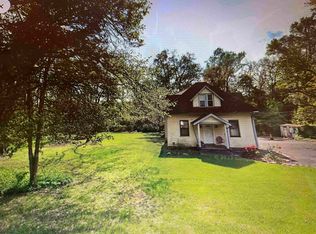
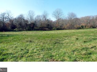
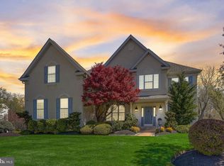
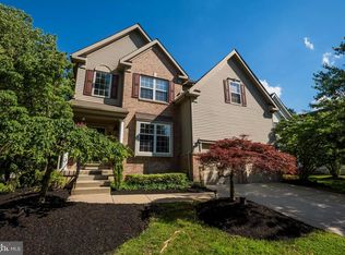
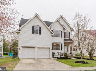
Updated*****Prime development opportunity in Mount Laurel with a completed, professional wetlands delineation. This 7.37-acre, four-parcel assemblage (Block 601, Lots 27, 28, 29 & 30.02) has been formally delineated by Wetlands & Ecology, Inc. (December 2025), confirming the presence and precise boundaries of NJDEP-regulated wetlands on the property. The delineation identifies six (6) discrete wetland areas, three of which are under 5,000 square feet and require no wetland transition area, with the remaining wetlands subject to standard transition requirements. The wetlands are anticipated to be classified as ordinary resource value wetlands, as they are not adjacent to Category 1 waters or trout-production waters. All wetland boundaries were mapped using GPS with ±2-foot accuracy, providing clarity for site planning and engineering. The property is located in the R-3 Residential District, supporting 20,000 sq ft minimum lot sizes, 100-foot lot width, and standard residential setbacks. With substantial upland area remaining outside of wetlands and transition zones, preliminary analysis supports the potential for multiple residential building lots, subject to buyer’s engineering, NJDEP verification, and Township approvals. Public sewer is located in the street and public water is on site. The prior Mount Laurel sewer moratorium has been lifted, allowing projects to proceed without delay. The property borders Sayebrook Estates, an established single-family neighborhood consistent with surrounding development patterns. For valuation context, a newer construction home directly across the street at 319 Mount Laurel Road sold in 2024 for $815,000 ($326 per square foot) on an R-3 compliant lot, offering a strong nearby benchmark for end-product pricing. Important Buyer Notice: All additional environmental investigations, including any Phase II Environmental Site Assessment, NJDEP Letters of Interpretation, permitting, approvals, mitigation, and compliance requirements shall be the sole responsibility of the buyer. Offering highlights include: Completed wetlands and State Open Waters delineation (December 2025) Clearly identified and mapped wetland boundaries Three wetlands under 5,000 sq ft with no transition area Significant contiguous upland suitable for development planning Four-parcel assemblage allowing flexible layout strategies A rare opportunity to advance a residential development project in one of Mount Laurel’s most desirable and supply-constrained corridors, now backed by verified environmental documentation that removes early-stage uncertainty while allowing buyers to control their own due diligence and approvals.
Lot/land
$799,500
324 Mount Laurel Rd, Mount Laurel, NJ 08054
--beds
--baths
7.37Acres
Unimproved Land
Built in ----
7.37 Acres Lot
$538,000 Zestimate®
$--/sqft
$-- HOA
What's special
- 105 days |
- 477 |
- 14 |
Zillow last checked: 8 hours ago
Listing updated: January 21, 2026 at 05:55am
Listed by:
Dae Jenkins 609-346-6929,
Keller Williams Realty - Moorestown
Source: Bright MLS,MLS#: NJBL2101376
Facts & features
Property
Lot
- Size: 7.37 Acres
Details
- Parcel number: 240060100027
- Zoning: RESIDENTIAL AND FARM
- Special conditions: Standard
Utilities & green energy
- Sewer: Septic Exists
- Water: Public
Community & HOA
Community
- Subdivision: The Gables At Mount Laure
HOA
- Has HOA: No
Location
- Region: Mount Laurel
- Municipality: MOUNT LAUREL TWP
Financial & listing details
- Tax assessed value: $329,300
- Annual tax amount: $10,395
- Date on market: 11/16/2025
- Listing agreement: Exclusive Right To Sell
- Listing terms: Cash,Conventional,FHA
- Ownership: Fee Simple
Estimated market value
$538,000
$425,000 - $662,000
$2,728/mo
Price history
Price history
| Date | Event | Price |
|---|---|---|
| 1/21/2026 | Listed for sale | $799,500 |
Source: | ||
| 12/4/2025 | Contingent | $799,500 |
Source: | ||
| 11/17/2025 | Listed for sale | $799,500+18.4% |
Source: | ||
| 10/2/2025 | Listing removed | $675,000 |
Source: | ||
| 7/2/2025 | Listed for sale | $675,000-3.6% |
Source: | ||
| 8/14/2024 | Listing removed | $699,997 |
Source: | ||
| 9/14/2023 | Listed for sale | $699,997-22.2% |
Source: | ||
| 9/4/2023 | Listing removed | $900,000 |
Source: | ||
| 2/9/2023 | Price change | $900,000-25% |
Source: | ||
| 3/25/2022 | Listed for sale | $1,200,000+72.7% |
Source: | ||
| 1/1/2018 | Listing removed | $695,000 |
Source: Weichert Realtors #1001755347 Report a problem | ||
| 6/26/2017 | Listed for sale | $695,000+379.3% |
Source: Weichert Realtors #7009287 Report a problem | ||
| 7/6/1998 | Sold | $145,000 |
Source: Public Record Report a problem | ||
Public tax history
Public tax history
| Year | Property taxes | Tax assessment |
|---|---|---|
| 2025 | $10,396 +3.9% | $329,300 |
| 2024 | $10,004 | $329,300 |
| 2023 | -- | $329,300 |
| 2022 | $9,971 +1.9% | $329,300 |
| 2021 | $9,784 +3.1% | $329,300 |
| 2020 | $9,494 +0.8% | $329,300 |
| 2019 | $9,421 +2.7% | $329,300 |
| 2018 | $9,178 +1.5% | $329,300 |
| 2017 | $9,039 +1.2% | $329,300 |
| 2016 | $8,934 +1% | $329,300 |
| 2015 | $8,845 -5.6% | $329,300 |
| 2014 | $9,368 +4.9% | $329,300 +59.9% |
| 2013 | $8,930 +1.6% | $205,900 |
| 2012 | $8,790 +0.3% | $205,900 |
| 2011 | $8,761 +4.8% | $205,900 |
| 2010 | $8,357 +2.1% | $205,900 |
| 2009 | $8,182 +2.5% | $205,900 |
| 2008 | $7,983 +4.4% | $205,900 |
| 2007 | $7,649 +4.1% | $205,900 |
| 2006 | $7,351 +5.7% | $205,900 |
| 2005 | $6,957 +2.4% | $205,900 |
| 2004 | $6,795 | $205,900 |
| 2003 | -- | $205,900 |
| 2002 | -- | $205,900 |
| 2001 | -- | $205,900 |
Find assessor info on the county website
BuyAbility℠ payment
Estimated monthly payment
Boost your down payment with 6% savings match
Earn up to a 6% match & get a competitive APY with a *. Zillow has partnered with to help get you home faster.
Learn more*Terms apply. Match provided by Foyer. Account offered by Pacific West Bank, Member FDIC.Climate risks
Neighborhood: 08054
Nearby schools
GreatSchools rating
- 5/10Hillside Elementary SchoolGrades: PK-4Distance: 1.1 mi
- 5/10T E Harrington Middle SchoolGrades: 7-8Distance: 1.2 mi
- 5/10Lenape High SchoolGrades: 9-12Distance: 3 mi
Schools provided by the listing agent
- District: Mount Laurel Township Public Schools
Source: Bright MLS. This data may not be complete. We recommend contacting the local school district to confirm school assignments for this home.
Local experts in 08054